05-02-2015, 07:23 PM
Hi all,
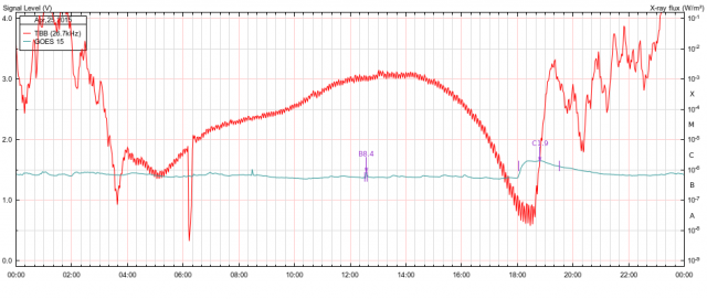
Just run across an article on today's "Spaceweather.com" about how the energy released during the 25th April Nepal Earthquake was detected in the Ionosphere using a GPS receiver. The receiver was in a neighboring region to Nepal, and though my system was off at the time, I did find a fellow monitorist in France, who did record a disturbance in one of his traces as the following image shows.

Like myself, he monitors several stations, the unaffected one's I've removed for better clarity, which leaves the red trace of TBB (Turkey). Note the time TBB goes off and on again, the quake occured at 06:11 UT, and TBB is the closest station he monitors to Nepal.
My system was off because I was still in bed at the time, Besides, all my gear is pointing at the ground .
.
Duffy,
Just run across an article on today's "Spaceweather.com" about how the energy released during the 25th April Nepal Earthquake was detected in the Ionosphere using a GPS receiver. The receiver was in a neighboring region to Nepal, and though my system was off at the time, I did find a fellow monitorist in France, who did record a disturbance in one of his traces as the following image shows.
Like myself, he monitors several stations, the unaffected one's I've removed for better clarity, which leaves the red trace of TBB (Turkey). Note the time TBB goes off and on again, the quake occured at 06:11 UT, and TBB is the closest station he monitors to Nepal.
My system was off because I was still in bed at the time, Besides, all my gear is pointing at the ground
 .
. Duffy,
 Logout
  Portal
  Forum
Forum Search
 Members
 Help
Help 

 )
)